MonuMAI-Open Data es una base de datos de imágenes de monumentos pública y rica en conocimiento experto, que ha sido creada en el contexto de nuestro proyecto de Ciencia Ciudadana MonuMAI.
MonuMAI es un proyecto de ciencia ciudadana de la Fundación Descubre y la Universidad de Granada que ofrece la oportunidad de acercarnos a los grandes estilos artísticos de la Andalucía Medieval y de la Edad Moderna, que son los que más han contribuido a la génesis de los centros históricos andaluces, aunando patrimonio, matemáticas e inteligencia artificial.
Gracias a este proyecto se ha desarrollado la App de MonuMAI y una base de datos en abierto. Se puede obtener más información en la respectiva publicación:
Lamas, Alberto & Tabik, Siham & Cruz, Policarpo & Montes, Rosana & Martínez-Sevilla, Álvaro & Cruz, Teresa & Herrera, Francisco. (2020) MonuMAI: Dataset, deep learning pipeline and citizen science based app for monumental heritage taxonomy and classification. Neurocomputing. doi.org/10.1016/j.neucom.2020.09.041
MonuMAI-Open Data es una base de datos de imágenes de monumentos pública y rica en conocimiento experto. Ha sido anotada por tres expertos usando dos tipos de anotaciones, lo que la hace útil para las tareas de clasificación del estilo arquitectónico de los monumentos y detección de elementos arquitectónicos clave.
Las imágenes utilizadas para la construcción de MonuMAI fueron seleccionadas de manera que el monumento esté centrado, ocupe la mayor parte de la imagen, y tenga una alta calidad para que las características del monumento puedan ser observadas. Las imágenes se seleccionaron de Internet y de cámaras de teléfonos inteligentes gracias a nuestra propia aplicación educativa MonuMAI para Android e iOS.
Clasificación de estilos arquitectónicos
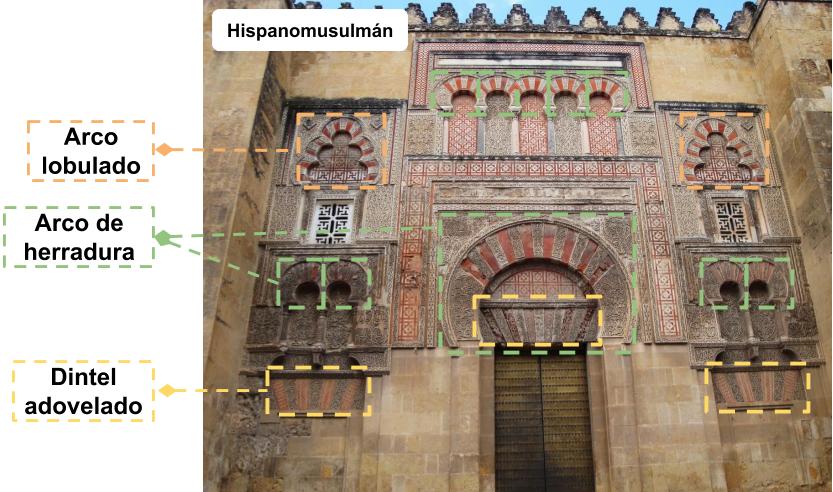
La primera versión de MonuMAI-Open Data contiene 1.514 imágenes RGB de fachadas de monumentos de cuatro estilos arquitectónicos: hispano-musulmán, gótico, renacentista y barroco. Las imágenes seleccionadas para la construcción de MonuMAI son adecuadas para clasificación gracias a que el monumento ocupa la mayor parte de la imagen.
Detección de elementos arquitectónicos clave
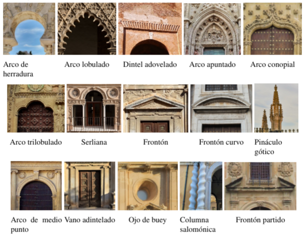
Además del etiquetado del estilo del monumento, en cada una de nuestras imágenes, se proporciona un conocimiento experto adicional sobre los elementos clave existentes. La zona donde se encuentra cada elemento característico de la imagen se delimita mediante un cuadro que es etiquetado con el nombre de uno de los quince elementos clave (ver figura). Los datos incluyen 6650 elementos clave anotados distribuidos en las quince clases de elementos arquitectónicos.
Descarga:
La base de datos de imágenes está organizada en carpetas por estilo. Además, las anotaciones xml están en carpetas específicas. Más detalle sobre la base de datos de monumentos y su acceso para descarga en el siguiente repositorio: https://github.com/ari-dasci/OD-MonuMAI
Fecha de publicación:
Julio de 2020
Contacto: