New AI Generative Satellite Imagery Models: Towards More Realistic and Reliable Visualisations of Climate Change
26 November, 2024
- Method could help communities visualise and prepare for upcoming storms
- University of Granada researcher Natalia Díaz is collaborating with MIT, among others, to generate new models for visualising natural disasters that are more realistic and reliable.
- The combination of deep learning and physics-based modelling reduces errors in the creation of synthetic satellite images for critical applications such as flood simulation.
A new study reveals that deep generative vision models can synthesise highly realistic satellite imagery useful for illustrating future climate events such as flooding, reforestation and sea ice retreat. Although this technology faces a critical challenge – ‘hallucinations’, or the generation of incorrect data in non-susceptible regions, which limits its applicability in risk-sensitive scenarios such as climate change communication – the new study applies physical constraints that greatly improve the plausibility of the visualisations and reduce hallucinations.
The study involved the participation of Natalia Díaz, a researcher at the DaSCI institute, University of Granada, in collaboration with several research centres and foundations in the United States, Canada, Germany and the United Kingdom, including the Massachusetts Institute of Technology (MIT).
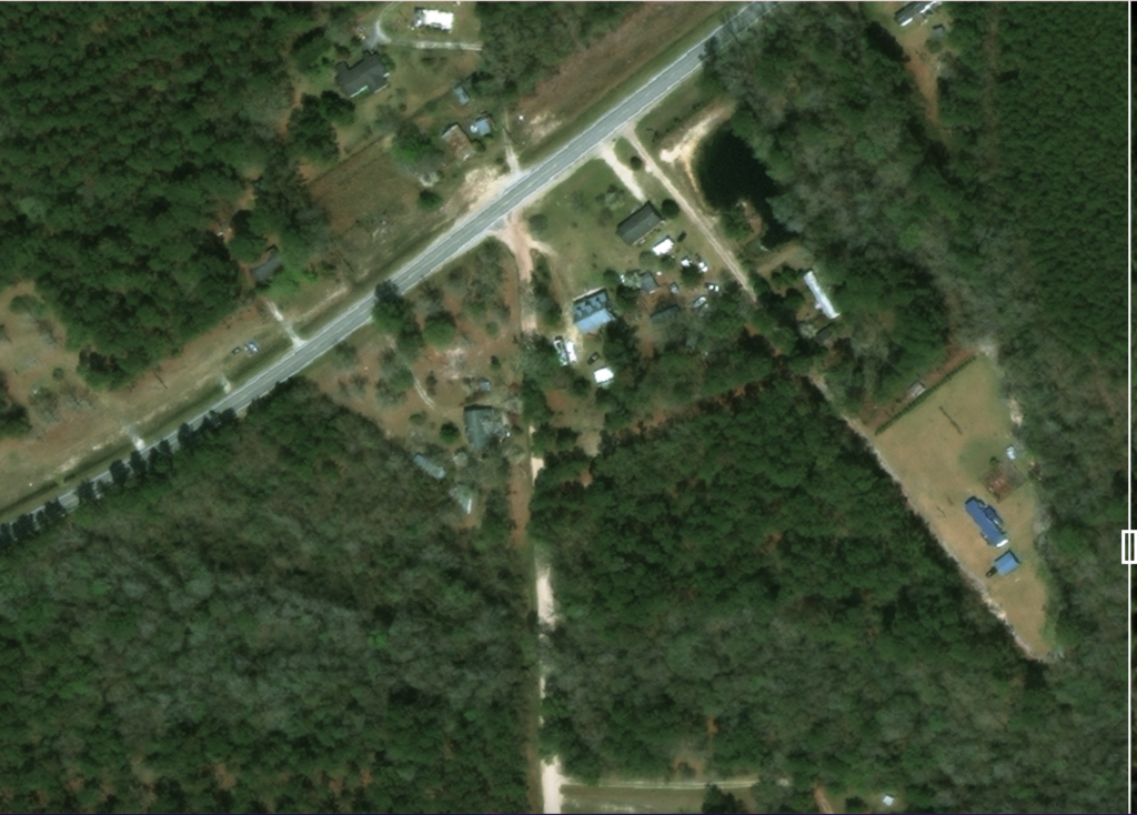
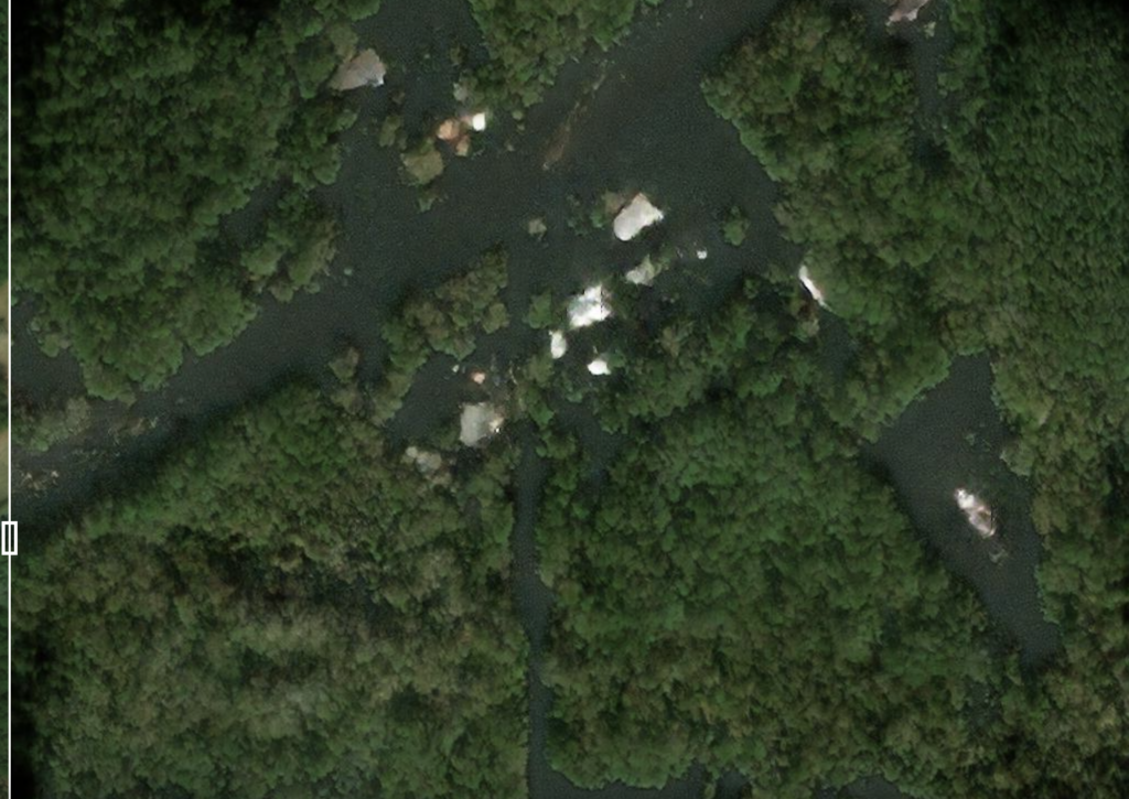
To address this problem, the team used a generative adversarial network (pix2pixHD) to create synthetic satellite images that will represent future floods or the result of positive actions such as reforestation. Initial results showed that, although the model was able to generate photorealistic images, it tended to ‘hallucinate’ floods in the wrong areas.
The proposed solution combines deep learning with segmentation maps generated by physics-based flood models. This improved approach outperforms not only the pure deep learning model, but also manual solutions, by significantly reducing prediction errors and improving the reliability of the images.
The team evaluated the generalisability of their method using different remote sensing datasets and climate events, including reforestation and melting Arctic sea ice. In addition, they have made their code, new metrics and an extensive dataset, including more than 30,000 HD image triplets labelled for segmentation-guided image-to-image translation, equivalent to 5.5 million images at 128×128 resolution, available to the scientific community.
This work marks a crucial step towards the creation of reliable and realistic visual tools for communicating climate change impacts, laying new foundations for collaboration between physics-based modelling and deep learning.
The Andalusian Inter-University Institute in Data Science and Computational Intelligence, known as DaSCI, is a collaborative entity between the universities of Granada, Jaén and Córdoba. It is dedicated to advanced research and training in the field of Artificial Intelligence, with a particular focus on Data Science and Computational Intelligence. The institute brings together an outstanding group of researchers working on joint projects, promoting the development and application of innovative technologies in various sectors. With the aim of becoming a benchmark in its field, the DaSCI promotes the transfer of scientific knowledge to the socio-economic environment, thus contributing to technological progress and the digitisation of industry. https://dasci.es/es/
- Example images generated by AI: Top: Pre-flood satellite image. Below: Image generated by the post-flood model.


Contact:
- Natalia Díaz-Rodríguez – nataliadiaz@ugr.es
More information:
- Original paper: B. Lütjens et al., “Generating Physically-Consistent Satellite Imagery for Climate Visualizations,” in IEEE Transactions on Geoscience and Remote Sensing,
- doi: 10.1109/TGRS.2024.3493763 2024
- Interacctive demo
- New at MIT
28/11/24 Desarrollan una IA que genera imágenes satelitales de futuras inundaciones y puede servir para evitar catástrofes https://cadenaser.com/nacional/2024/11/28/desarrollan-una-ia-que-genera-imagenes-satelitales-de-futuras-inundaciones-y-puede-servir-para-evitar-catastrofes-cadena-ser/
28/11/24 Crean una herramienta de IA que genera imágenes satelitales de futuras inundaciones https://www.infobae.com/espana/agencias/2024/11/28/crean-una-herramienta-de-ia-que-genera-imagenes-satelitales-de-futuras-inundaciones/
28/11/24 Nueva herramienta de inteligencia artificial genera imágenes satelitales realistas de futuras inundaciones https://www.ucodigital.com.ar/smartwatch/nueva-herramienta-de-inteligencia-artificial-genera-imagenes-satelitales-realistas-de-futuras-inundaciones/107748/
28/11/24 Crean una herramienta de IA que genera imágenes satelitales realistas de futuras inundaciones https://www.msn.com/es-es/noticias/tecnologia/crean-una-herramienta-de-ia-que-genera-im%C3%A1genes-satelitales-realistas-de-futuras-inundaciones/ar-AA1uVdg5
28/11/24 Una nueva herramienta de IA genera imágenes satelitales realistas de futuras inundaciones https://www.iagua.es/noticias/redaccion-iagua/nueva-herramienta-ia-genera-imagenes-satelitales-realistas-futuras
28/11/24 Desarrollan una nueva herramienta de IA para visualizar inundaciones futuras https://www.20minutos.es/noticia/5658711/0/desarrollan-una-nueva-herramienta-ia-para-visualizar-inundaciones-futuras/
28/11/24 Crean una herramienta de inteligencia artificial que genera imágenes satelitales realistas de futuras inundaciones https://www.europapress.es/andalucia/noticia-crean-herramienta-inteligencia-artificial-genera-imagenes-satelitales-realistas-futuras-inundaciones-20241128144640.html
28/11/24 Crean una herramienta de inteligencia artificial que genera imágenes satelitales realistas de futuras inundaciones https://canal.ugr.es/noticia/crean-una-herramienta-de-inteligencia-artificial-que-genera-imagenes-satelitales-realistas-de-futuras-inundaciones/
28/11/24 Un nuevo herramienta de IA crea imágenes satelitales realistas para anticipar las inundaciones futuras https://actu.ai/es/un-nuevo-herramienta-de-ia-crea-imagenes-satelitales-realistas-para-anticipar-las-inundaciones-futuras-12186.html
28/11/24 El Motor de Inteligencia Terrestre de MIT: Predicción de Inundaciones Impulsada por IA https://neuron.expert/news/new-ai-tool-generates-realistic-satellite-images-of-future-flooding/9518/es/
28/11/24 IA para Visualizar Inundaciones Futuras: Innovación o Riesgo? https://iartificial.blog/aplicaciones/ia-visualizar-inundaciones-futuras/
28/11/24 Herramienta de IA que genera imágenes de satélite realistas para evitar desastres naturales co https://www.pcdemano.com/sc/31812/
28/11/24 Desarrollan una nueva herramienta de IA para visualizar inundaciones futuras https://www.rednoticias.eu/new/desarrollan-nueva-herramienta-ia-visualizar-inundaciones-futuras
28/11/24 Investigadores de la UGR crean un generador autónomo de problemas de IA capaz de mejorar las aplicaciones de mapas https://www.granadaesnoticia.com/universidad/investigadores-de-la-ugr-crean-un-generador-autonomo-de-problemas-de-ia#goog_rewarded
28/11/24 Crean una herramienta de inteligencia artificial que genera imágenes satelitales realistas de futuras inundaciones http://www.cibersur.com/cibersur/impe/iadministracion/023515/crean/herramienta/inteligencia/artificial/genera/imagenes/satelitales/realistas/futuras/inundaciones


